Distance: 47.5 miles (scroll down for the Strava map)
Less then 48 hours
until the clocks spring forward for the start of Summer Time and I'm
staring out the window, wondering if the snow is sufficiently heavy
for my bike ride to be cancelled. I put the coffee machine on,
decided to wait and see how the weather developed. Half an hour and
two very strong coffees later, I'm on the road, the snow's stopped,
the sun's out but the skies on the horizon are dark and doom-laden.
Nevermind, at least I'm
out. That was probably the hardest part of this ride, breaking that
imaginary barrier, overcoming my meteorological doubts and exiting
the flat. (How much improved as a cyclist would I be had the hours of
weather watching and dithering instead been spent on the bike and
riding?) Anything
can happen now that I'm actually out, on the road and pedaling —
rain, snow, lightning, storm of locusts, zombie invasion — it would only help to embellish the tales I'd tell when safely back in the
flat, returned to staring out the window at the weather.
I headed out through
town, away from the canal, up through Bruntsfield, across the
Meadows, into Holyrood Park and on toward Meadowbank. I was in a
contemplative mood and so paid sufficient attention to realise just
how pretty a city Edinburgh is. In five minutes I was treated to
stunning scenes of the Georgian skyline presided over by the Castle,
the imposing crags of Arthurs Seat, then down the hill passed Parliament
and Palace. I'd have taken some photos but removing my gloves put me
at risk of frostbite and I kept thinking: I see this every day; I'll
take some photos another time.
 |
| Portie Prom |
Passed Meadowbank with
its stadium and dilapidated Velodrome, I rolled on down toward Portobello (a separate seaside town that's become subsumed by
the city). Rather than battle the traffic through the town I chose to
meander along the prom', dodging joggers and excited dogs, struggling
to resist the aromas of fried food and coffee that leaked from the
many cafés.
Out through Joppa, I
turned left and long the coast road, through Musselburgh (the poor
man's Portobello), passed the race course and left toward Prestonpans
(named after its salt-panning origins). That stretch, which should
have been a scenic warm-up, was proving a tougher task, the wind
against me, keeping those twin towers distressingly distant.
Eventually out through
the Pans (as the locals call it) and I stopped to snap a photo of the
power station and its chimneys. (I also took the gloveless
opportunity to fish an energy bar from my back pocket.) The
ugly-yet-imposing place really is a local landmark. I wondered what
would happen to it now that the facility had been decommissioned,
taken off-grid. Would it be listed, turned into a residential and
leisure development like London's Battersea? Or left to rot, crumble
and, eventually, tumble?
 |
| Cockenzie Power Station |
I battled on, through
Cockenzie and Port Seton, the road still following the coast but
ducking into tree-filled stretches that provided a little shelter
from the wind. As that cover fell away my time came to turn inland,
away from the coast and into Longniddry.
The road into the
village passed the impressive arched gateway to the Wemyss Estate
with it's carved motto: je pense forward. I thought and rode
straight ahead — then turned right, through the village, before a
left, under the railway line and on into open countryside (headed
toward Pentcaitland).
My views until then had
been mostly blue sky and sea. The coastline behind me, I now had dark
skies, barren fields and snow-covered hills for encouragement and
entertainment. It looked daunting: I reached into my back pocket for
another energy bar. Je pense forward.
When I got there,
Pentcaitland was a pretty little place, a stone's throw from
Scotland's capital city but looking and feeling thoroughly rural. I
stayed on the narrow road through the village (resisting the urge to
stop and investigate a sign that offered “hot drinks & hot
food”), crossing the River Tyne (no, not the River Tyne)
following the directions for Dalkeith.
The road was now
undulating nicely and the wind wasn't making much impression. It had,
however, started to snow and the skies ahead were blacker than the
tarmac along which I was rolling. I was in the mood for thinking
backward, to the blue sea and sky I recently departed.
After a few miles I
took the left turn to Pathhead, onto a less amenable road. Within a
few minutes of the turn, the snow had stopped and the sun was out. I
unzipped my jacket and swigged from my bidon, gone from stressing
about being under-dressed to wondering if I might have worn a layer
too many.
 |
| Mur de Ford |
Through Pathhead I took
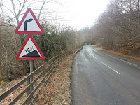
the left turn to Ford, noticing a signpost that warned of a 12%
gradient. Doesn't bother me, I thought, as I freewheeled downhill,
before reaching the bottom and remembering that what goes down must
come up (unless of course you want to ditch the bike and start a new
life at the bottom of the hill).
The Mur de Ford, as it shall
henceforth be known, was the first real ascent of the day and my legs
failed to show any signs of appreciation.
At the top of the Mur
was a left turn to Gorebridge (once a mining village, now a former
mining-village, like many outposts in this part of the world).
Through Gorebridge and I followed the signs for Penicuik. The
landscape had opened out again to reveal those snow-covered hills,
now looking much more like snow-covered mountains. Time for another
energy bar.
Either the energy bar
was an extra special specimen or the wind was behind me, for I took
the next few miles in my stride, turned left just before the village
of Temple and on through the wooded valley to Carrington (the least
Dynasty place on the planet). You can tell you're short of fuel on a
ride when a farm's hand-painted sign selling free-range eggs makes
your stomach rumble.
 |
| Carrington Church |
Up the wee rise and out
of Carrington and I was back on more familiar roads, the sight of
those not-so-distant snowy mountains (the Pentlands) no longer
delivering dread. All I had to do was drop down the hill into Roslin
Glen, climb up the other side and I'd be (almost) home. The 16%
gradient of that climb took me down into third gear and forced out a
rather tired sigh but was soon over and done with. I turned left
(away from the village and the chapel made famous by The Da
Vinci Code) and onto the main Edinburgh Road.
 |
| You've Been Warned |
I kept it in the big
ring all the way home from there — although, it took a few jelly
babies from my emergency rations, and a good deal of Thomas Voeckler
face-pulling on the last climb (up to Fairmilehead) to do so.
Downhill all the way
from there. Back to the flat for a bacon butty, hot, sweet lapsang
souchong and an even hotter bath. My last winter bike ride was behind
me, if only I could have said the same for the winter weather.
There's a full map of
the route here on Strava.
Click here to view all
the photos on Flickr.

No comments:
Post a Comment